I am putting together the itinerary for our trip to visit my brother, Isaiah in Las Cruces, NM for Christmas and exploring the options for a part of the world that I have never visited! I have so many tabs open in Firefox of places we could go see that I need to just put them all in a list so I can remember them! It is so hard to limit a trip when I keep thinking, “While we’re there, we should just visit ______ (fill in blank), it is only a couple of hours out of our way! So, for future family excursions here is my list of places I want to see next time we are in that neck of the woods… I’m sure I will be adding to it as time goes by!
Vermilion Cliffs National Monument
General trail information for Vermilion Cliffs here. The Wave is my top choice of these destinations. However, it is the top choice for so many others! Sadly, the BLM has placed so many restrictions for visiting that the chances of getting a permit are sometimes less than 2%. They have an online lottery that gives out 10 (yes, you read correctly, TEN) permits per day, year round, three months in advance. They grant ten more, again by lottery at the Kanab Ranger office daily. I like this site for explaining the system. When we are ready to try our luck I will go the the BLM website to apply for a permit.
The Wave
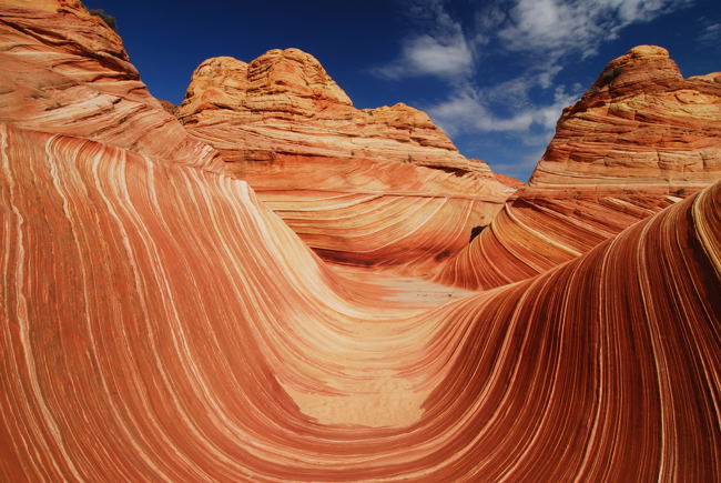
Photo from freeyork.com
White Pocket

For more information on White Pocket go here. The road to the trail head is very long with at least 13 miles of up to twelve inch sand! I’m pretty sure we won’t be attempting this route until we install a winch and some locking differentials on our van to get the back tires to spin together. Maybe next year? Permits are not required for this hike.
Antelope Canyon

Antelope Canyon with the Iconic Sunbeam. Photo from Biotrip.com
What I have learned about Antelope Canyon (outside of Page, Arizona): This beautiful place is part of the Navajo Nation and cannot be accessed except by expensive guided tours. (Cheapest price I found was about $30/person for 1 1/2 hours). I like the description of optimal tour times here. For information on booking tours go here. Also, if you would rather you can just drive up to the trail head and get a guide there. Word is the guides are there to make sure you behave, and not, for the most part, to give you any information. You can visit both Upper and Lower Antelope Canyons. Lower is a lot less busy, is less accessible (ladders and tight passages) but is not as narrow or deep as the upper canyon. I’ve read that you want to be there on a sunny day when the sun is high for best colors. Winter is not the best time to go as the sun doesn’t get as high in the sky.
Mule Canyon and Cedar Mesa Ruins
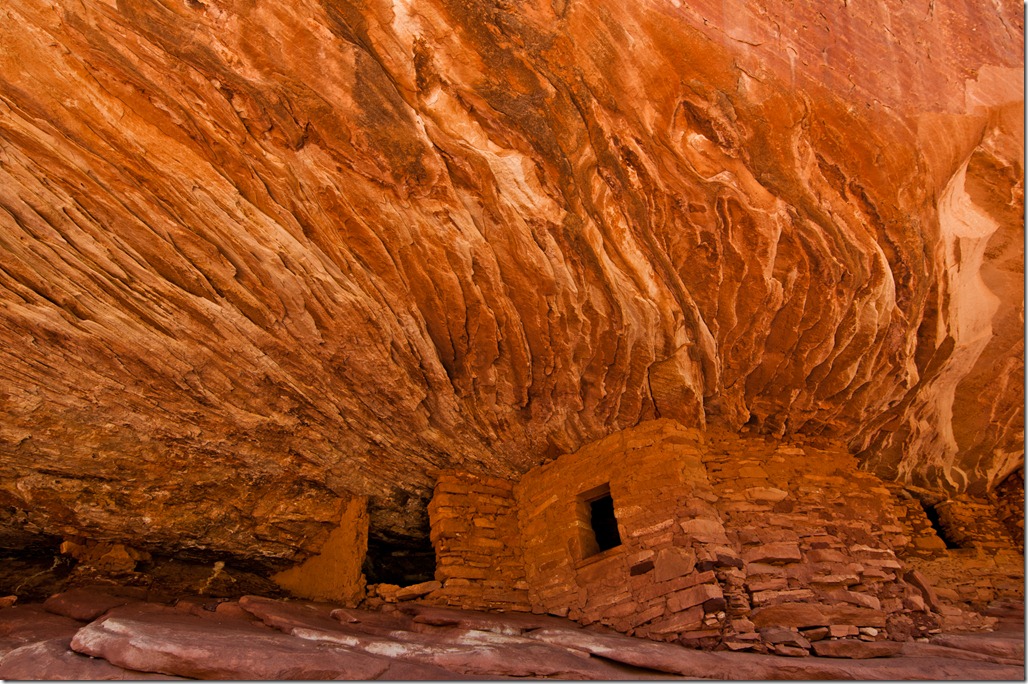
House on Fire Ruins at Cedar Mesa. Photo from My Way is the Highway
This is a nice description of this hike found on utahadvjournal.com:
If you’re in the mood for isolation, then a hike through Mule Canyon will provide; that is unless you don’t mind the spirits of an extinct civilization keeping you company. In fact, the primary reason to explore Mule Canyon shouldn’t be as an excuse for antisocial behavior, but to check out the many ancient Anasazi ruins nestled inside nooks and overhangs along the canyon walls.
The ruins of Mule Canyon were occupied between 750 and 1300 AD, and archeologists still aren’t sure why these cliff dwellers vanished from the land, leaving behind their homes that remain to this day. But the fact that the stone and mortar structures are still standing makes Mule Canyon a truly special place.
What’s really amazing is that the Mule Canyon trailhead begins right off Highway 95 between Blanding and Natural Bridges National Monument, yet it sees few visitors. All it takes to begin this hike is a short drive on a dirt road into the creek bed, and the place is yours.
Mule Canyon is a 10 mile round-trip hike that starts at the bottom of the canyon and winds up through juniper forests that grow along the sandstone walls and alcoves. After just over a mile, the first of several Anasazi ruins appears, hunkered down behind some trees and a giant roof. You have to keep a sharp eye and constantly scan the shadows and natural amphitheaters to see the ruins, as there are no signs advertising their locations.
As you walk up canyon, several more houses and granaries are revealed, though some are more impressive than others. Time has worn away many of the more exposed ruins, while leaving the sheltered buildings practically untouched. The best example of a well-preserved ruin is about five miles in, at the junction of two smaller canyons where the canyon floor is an oasis of ponderosa pines. It is the largest ruin of them all, filled with numerous rooms that snake back into the cliffside. Pottery shards litter the ground, whole rooms are intact with roofs blackened by campfires that burned hundreds of years ago. The back rooms are so dark that a headlamp or camera flash must be used to peer inside and make a startling discovery.
A door. Still sealed with a mortared, flat stone. The mind swims with the possibilities of what may be inside. Pottery? Petrified corn? Perhaps even an Anasazi grave lies behind the rock. Amazingly, there are other unopened doors throughout the ruin. Curiosity can be overwhelming, but it is not for us to disturb these sites. We must only observe and let history remain in stasis, so those who come behind us can enjoy the same discoveries.
If You Go:
Drive west on Highway 95 from Blanding. In 24 miles, leave the highway on the gravel-covered Texas Flat Road. You will see a sign marking the Mule Canyon trailhead on the left. To enjoy the hike, the BLM asks you to register and pay $2 at a fee box, located off the highway. The ruins of Mule Canyon are a national treasure, and must be treated with respect. It is best not to enter them, but if you do, be careful not to touch the walls and always leave artifacts like pottery shards where you found them. Help keep our archaeological sites preserved.
Info on how to get a permit here.
Other Indian rock art in the area that I want to see can be found here.
For a map of Utah petroglyphs and ruins go here.
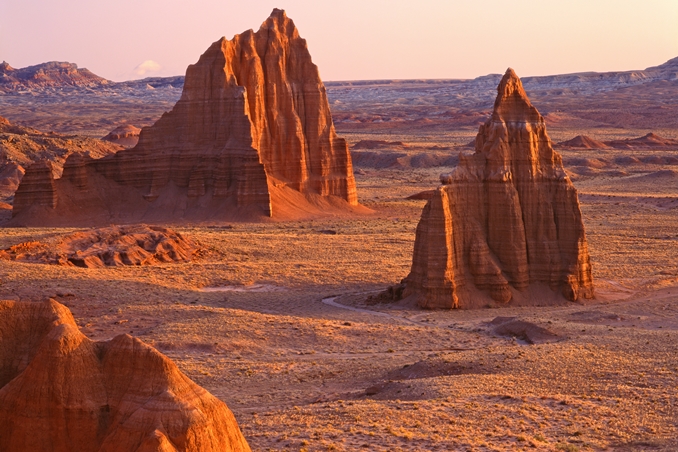
Capitol Reef
We have been to a few parts of of lower Capitol Reef including the Pioneer Register (very cool), the tanks trail, The Grand Wash. There is something about Capitol Reef that I love so much but I can’t quite put my finger on what exactly I love. It is one of my favorite places in Utah. It is less visited than some of the other parks in Utah but equally majestic. Maybe I love it because it has such a nice campground in Fruita? Maybe because the of the lovely drive getting there, the stretch of road from Torrey to Hanksville is stunning. For Information on Capitol Reef go here and here
Cathedral Valley
Lower Muley Twist Canyon
Lower Muley Twist Canyon and Hamburger Rock: From Explore Utah: 6 miles with car shuttle. Located in the southern district of Capitol Reef National Park, this is a day hike with overnight options through a remarkable section of the Waterpocket Fold. This route takes hikers through a deep canyon in a remote wilderness with splendid vistas, gaining a historical perspective on the Mormon pioneers who passed through this area in the late 1800s.
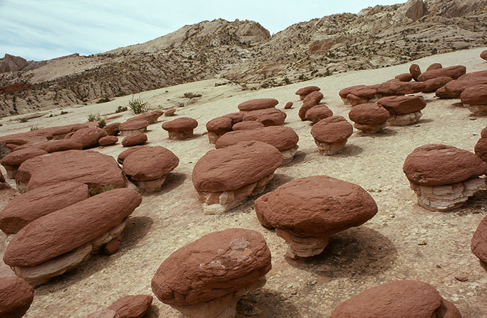
Hamburger Rocks
Halls Creek Canyon

Photography by Frans Lanting
Trail guide here
Mesa Verde National Park

Mesa Verde National Park. © Jim Shoemaker Photography
I think we will be visiting this spot on our way back from Isaiah’s at Christmas. The only problem is the only part of the park that is available to tour during the winter is Spruce Tree House because Cliff Palace and Balcony House are both closed. I would still like to go at Christmas mainly because I feel like we might as well since it is so close to our route and also because part of me is nervous that places like this will soon restrict number of visitors or access like so many other parks are doing. Visitor’s guide here.